Google Earth 6 doesn't have too many new features. You can now use Street View just like in Google Maps by dragging the pegman icon. "To view street-level imagery for a specific location, zoom into an area at an altitude of approximately 500km. You will see a pegman icon appear at the top right below the navigation controls. Click and drag the icon across the 3D viewer. A blue border will appear around roads that have street-level imagery available," explains Google.
Another new feature is the "3D Trees" layer that can be enabled from the "3D Buildings" section. Google Earth includes 3D models for city parks (San Francisco, Chicago, Tokio, Athens) and remote forests (Amazon Forest).
Historical imagery is now more accessible: just click on the date of the oldest imagery in the status bar and you'll be able to see all the historical images that are available for the same location.
Google Earth 6 also adds ground-level navigation that lets you explore 3D buildings and 3D trees, 3D measurements for heights and widths of buildings and a much better Tour Recorder that improves motion fidelity.
Showing posts with label Google Earth. Show all posts
Showing posts with label Google Earth. Show all posts
Google Earth Includes a Web Browser
Google Earth 5.2 no longer uses the operating system's web browser when you click on links. Google Earth comes with a WebKit-based browser, so you'll never have to leave the application to open a Wikipedia page or the website of a local business.
"Sometimes when you want more information, you may want to click through to a link to see the full Google Places page for a business, or learn more about a photographer whose photo you really enjoy. In the past, this has required opening a link in an external browser to see the full page. For Google Earth 5.2, we've added an embedded browser that lets you browse the full web. Click on a link, and the browser pane slides across the screen. When you want to return to the Earth view, just click the Back button," explains Google.


Apparently, Google Earth uses the Qt port of WebKit (QtWebKit) and it doesn't include the V8 Javascript engine from Google Chrome. I tried to run the V8 benchmark suite in Google Earth and the result was very poor: about 10 times lower than the latest Chromium build.
As in the previous versions, Google Earth for Windows and Mac also includes a plug-in that lets you embed a Google Earth view in any web page. Google Maps is the most popular service that lets you use Google Earth in your browser. Now you can browse the Web in Google Earth and use Google Earth in a Web browser.
If you don't like the embedded browser, you can disable it by going to Tools > Options > General and checking "Show web results in external browser".
"Sometimes when you want more information, you may want to click through to a link to see the full Google Places page for a business, or learn more about a photographer whose photo you really enjoy. In the past, this has required opening a link in an external browser to see the full page. For Google Earth 5.2, we've added an embedded browser that lets you browse the full web. Click on a link, and the browser pane slides across the screen. When you want to return to the Earth view, just click the Back button," explains Google.
Apparently, Google Earth uses the Qt port of WebKit (QtWebKit) and it doesn't include the V8 Javascript engine from Google Chrome. I tried to run the V8 benchmark suite in Google Earth and the result was very poor: about 10 times lower than the latest Chromium build.
As in the previous versions, Google Earth for Windows and Mac also includes a plug-in that lets you embed a Google Earth view in any web page. Google Maps is the most popular service that lets you use Google Earth in your browser. Now you can browse the Web in Google Earth and use Google Earth in a Web browser.
If you don't like the embedded browser, you can disable it by going to Tools > Options > General and checking "Show web results in external browser".
Google Earth Tab in Google Maps
Google Maps replaced the terrain tab with a tab for Google Earth. When you click on the Earth tab, Google asks you to install a plug-in for Windows or Mac. If you have a recent version of Google Earth, you already have the plug-in.
"Five years ago, shortly after Google's acquisition of Keyhole, we introduced the first integration of Keyhole technology into Google Maps -- Satellite view. Suddenly, you could see what places actually looked like from the air, and easily switch between this view and the map view. Mapping has never been the same. A few months later, the desktop Google Earth application was released, and now we have over 600 million downloads. Today we are proud to announce the next major step in the marriage between Google Earth and Google Maps -- Earth view," says Peter Birch, from Google.
Even though the new view makes it easier to use Google Earth, since you no longer have to open a new application, I think it's a bad idea to add it to Google Maps. Google Earth plug-in uses a lot of resources, it slows down your browser and it continues to run in the background even if you switch to the Map tab. What's more, if you open Google Maps in another window and switch to the Earth tab, a new instance of the Google Earth plug-in will load.

{ Thanks, Andrew. }
"Five years ago, shortly after Google's acquisition of Keyhole, we introduced the first integration of Keyhole technology into Google Maps -- Satellite view. Suddenly, you could see what places actually looked like from the air, and easily switch between this view and the map view. Mapping has never been the same. A few months later, the desktop Google Earth application was released, and now we have over 600 million downloads. Today we are proud to announce the next major step in the marriage between Google Earth and Google Maps -- Earth view," says Peter Birch, from Google.
Even though the new view makes it easier to use Google Earth, since you no longer have to open a new application, I think it's a bad idea to add it to Google Maps. Google Earth plug-in uses a lot of resources, it slows down your browser and it continues to run in the background even if you switch to the Map tab. What's more, if you open Google Maps in another window and switch to the Earth tab, a new instance of the Google Earth plug-in will load.
{ Thanks, Andrew. }
Offline Installer for Google Earth
Downloading Google Earth is more complicated than it should be. At least if you want to download only Google Earth and save the installer for a future use. By default, Google downloads a small setup file that installs Google Earth, Google Chrome and Google Updater. Even if you disable the option "Include Google Chrome, a fast new browser for Windows and Mac", you'll still download a Web installer.
Here's how to download the standalone installer for Google Earth:
1. Go to Google Earth's homepage and click on "Download Google Earth".
2. At the bottom of the page, there's a small message: "Customize your installation with advanced setup." Click on "advanced setup".
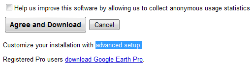
3. Disable this option: "Allow Google Earth to automatically install recommended updates."
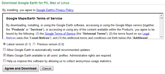
4. Click on "Agree and download" and you'll get the offline installer. The direct download link for the Windows version is: http://dl.google.com/earth/client/advanced/current/GoogleEarthWin.exe.
The advanced setup page offers two other interesting options: installing Google Earth for all user accounts and the full setup for Google Earth 5.0.
Google Chrome should add a similar page that lets you download the standalone installer and a version that installs the software for all user accounts. This page still offers the standalone setup, but it's an old version. Right now, Google Pack is the only option to install Chrome for multiple user accounts.
{ Thanks, Brian. }
Here's how to download the standalone installer for Google Earth:
1. Go to Google Earth's homepage and click on "Download Google Earth".
2. At the bottom of the page, there's a small message: "Customize your installation with advanced setup." Click on "advanced setup".
3. Disable this option: "Allow Google Earth to automatically install recommended updates."
4. Click on "Agree and download" and you'll get the offline installer. The direct download link for the Windows version is: http://dl.google.com/earth/client/advanced/current/GoogleEarthWin.exe.
The advanced setup page offers two other interesting options: installing Google Earth for all user accounts and the full setup for Google Earth 5.0.
Google Chrome should add a similar page that lets you download the standalone installer and a version that installs the software for all user accounts. This page still offers the standalone setup, but it's an old version. Right now, Google Pack is the only option to install Chrome for multiple user accounts.
{ Thanks, Brian. }
Google Earth 5.1 Is Faster
Google's 3D Earth browser has been updated and the latest build, 5.1.3506.3999, loads faster and it's snappier.
"We've made a lot of adjustments under the hood, like improving memory utilization so we can show more buildings, layers, and user content. We improved our shaders (that's graphics-speak for small programs that run inside your graphics processor) to make the atmosphere draw faster. We also worked to reduce stuttering (known as frame drops) to provide an even smoother experience as you fly around the globe. When we draw imagery, we now use compression technology to use less memory and graphics resources. We know that waiting for a program to start-up can be really frustrating, so we improved our start-up time by 25%," mentions Google LatLong blog.

While the performance improvement is noticeable, Google Earth continues to use a lot of resources. In a small empirical test, I compared the latest release with an earlier version and the results are even better than Google's claims:
Update: If you want to download Google Earth without installing Google Updater, here's the direct download link for Windows. This build includes the plug-in for IE/Firefox/Chrome that lets you use Google Earth inside a browser. That means you'll end up with three different Google Earth versions when you upgrade: the old version, which for some reason is not removed, the new version of Google Earth and the plug-in, which wastes 33 MB by including separate copies of the files used by Google Earth.
"We've made a lot of adjustments under the hood, like improving memory utilization so we can show more buildings, layers, and user content. We improved our shaders (that's graphics-speak for small programs that run inside your graphics processor) to make the atmosphere draw faster. We also worked to reduce stuttering (known as frame drops) to provide an even smoother experience as you fly around the globe. When we draw imagery, we now use compression technology to use less memory and graphics resources. We know that waiting for a program to start-up can be really frustrating, so we improved our start-up time by 25%," mentions Google LatLong blog.
While the performance improvement is noticeable, Google Earth continues to use a lot of resources. In a small empirical test, I compared the latest release with an earlier version and the results are even better than Google's claims:
| Google Earth version | Start-up time | Memory usage when searching for "Paris" |
| Google Earth 5.0.11337.1968 | 11.5 seconds | 183 MB |
| Google Earth 5.0.11733.9347 | 10.4 seconds | 164 MB |
| Google Earth 5.1.3506.3999 | 6.9 seconds | 145 MB |
Update: If you want to download Google Earth without installing Google Updater, here's the direct download link for Windows. This build includes the plug-in for IE/Firefox/Chrome that lets you use Google Earth inside a browser. That means you'll end up with three different Google Earth versions when you upgrade: the old version, which for some reason is not removed, the new version of Google Earth and the plug-in, which wastes 33 MB by including separate copies of the files used by Google Earth.
Explore the Moon in Google Earth
After adding the ocean, the sky, Mars, Google Earth now has imagery from the Moon. Forty years after the Moon landing, you can explore the Earth's natural satellite in 3D.

"Each of the Apollo landing missions is chronicled in detail through pictures and stories. We've even embedded video footage from Spacecraft Films that covers the most well-known moments on the surface. There are also immersive lunar surface panoramas, composed of photos taken by the astronauts themselves, presented for the first time in a 3D Street View style interface," explains Google.
To see the Moon, you need a recent version of Google Earth: after installing the software, click on the planet button from the toolbar and select "Moon".
"Each of the Apollo landing missions is chronicled in detail through pictures and stories. We've even embedded video footage from Spacecraft Films that covers the most well-known moments on the surface. There are also immersive lunar surface panoramas, composed of photos taken by the astronauts themselves, presented for the first time in a 3D Street View style interface," explains Google.
To see the Moon, you need a recent version of Google Earth: after installing the software, click on the planet button from the toolbar and select "Moon".
Visit DisneyLand Paris Using Google Street View
Disneyland Paris is the first amusement park available in Google Street View. "Last October, as the last few rays of sunlight remained high enough in the sky, Disneyland Paris opened its gates early to our Street View car to capture some of the magic at street-level. We drove up Main Street USA (outside of Paris!), through Adventureland, and around Fantasyland and even in Walt Disney Studios Park," explains Google.

This shows some important uses of Google Street View: helping tourists plan itineraries and conducting virtual field trips.
You can also view an impressive 3D model of Disneyland Paris in Google Earth. "More than 85,000 photos (450GB worth) were taken over a 20 day period for this project. The castle alone is comprised of over 354 textures derived from over 2,000 photos. (...) There are over 500 unique landscape elements that were created to make the park look as realistic as possible."
The unofficial Google Earth blog reports that Google added a lot of new 3D buildings. "Google has been slowly adding cities using an unpublished methodology where vast numbers of buildings for large areas of cities are being rendered in 3D with photorealistic textures. The photos appear to be aerial in some cases, in others they seem to be from the ground. But, they are using an at least semi-automated process judging from the cases where some buildings are not properly dressed with the photo textures."
This shows some important uses of Google Street View: helping tourists plan itineraries and conducting virtual field trips.
You can also view an impressive 3D model of Disneyland Paris in Google Earth. "More than 85,000 photos (450GB worth) were taken over a 20 day period for this project. The castle alone is comprised of over 354 textures derived from over 2,000 photos. (...) There are over 500 unique landscape elements that were created to make the park look as realistic as possible."
The unofficial Google Earth blog reports that Google added a lot of new 3D buildings. "Google has been slowly adding cities using an unpublished methodology where vast numbers of buildings for large areas of cities are being rendered in 3D with photorealistic textures. The photos appear to be aerial in some cases, in others they seem to be from the ground. But, they are using an at least semi-automated process judging from the cases where some buildings are not properly dressed with the photo textures."
Chat With a Martian in Google Earth 5
Open the latest version of Google Earth, switch to "Mars" and search for "Meliza". Click on the small robotic icon and you'll be able to chat with Meliza, a friendly relative of Eliza, one of the first chat bots. A message informs Earthlings that "Meliza is using an account on a different planet. There may be translation errors." The chat bot has some predefined text related to Mars and it can't answer to many questions, but it's always ready to rephrase your messages.
Here's Meliza's first message: "Greetings, Earthling! What do you think of Google Mars?Have you checked out Valles Marineris? It's like the Grand Canyon, but bigger. Mars is so much better than Earth!"

In other news, Google and NASA sponsor Singularity University. "In 2005, futurist Ray Kurzweil published The Singularity Is Near, a comfort-rattling forecast of a few decades hence when artificial intelligence will overtake human capability and an array of other huge leaps will fundamentally alter our lives. Now, Kurzweil is helping to launch a university rooted in the book's predictions. In June, Singularity University is scheduled to open with a faculty replete with scientific celebrities, and an initial class of 30 students at NASA's Ames Research Center in Silicon Valley."
{ Thanks, Tom. }
Here's Meliza's first message: "Greetings, Earthling! What do you think of Google Mars?Have you checked out Valles Marineris? It's like the Grand Canyon, but bigger. Mars is so much better than Earth!"
In other news, Google and NASA sponsor Singularity University. "In 2005, futurist Ray Kurzweil published The Singularity Is Near, a comfort-rattling forecast of a few decades hence when artificial intelligence will overtake human capability and an array of other huge leaps will fundamentally alter our lives. Now, Kurzweil is helping to launch a university rooted in the book's predictions. In June, Singularity University is scheduled to open with a faculty replete with scientific celebrities, and an initial class of 30 students at NASA's Ames Research Center in Silicon Valley."
{ Thanks, Tom. }
Google Earth 5 Plus the Ocean
Google Earth 5, the latest version of Google's 3D geo-browser, brings an important feature from the discontinued Google Earth Plus, which used to cost $20/year. You can now read tracks and waypoints from a GPS device like Magellan and Garmin and you can import GPS files in GPX and LOC format.
Another interesting new feature is the ability to visualize geographical changes over time. Google Earth shows historical imagery that goes back to the 40s in some places like San Francisco.

If you find an interesting way to visualize a location, there's a new "record a tour" option that saves the places you visit in Google Earth and lets you replay the tour. Unfortunately, you can't export a tour in a video format using the free version of Google Earth, but the good news is that you can record a voice commentary.
Google Earth is no longer just about the Earth and stars, now you can use it to view imagery and terrain of Mars by clicking on the planet icon.

While all these additions useful, you'll most likely download Google Earth 5 to explore the ocean. "Dive beneath the surface and visit the deepest part of the ocean, the Mariana Trench. Explore the ocean with top marine experts including National Geographic and BBC. Learn about ocean observations, climate change, and endangered species. Discover new places including surf, dive, and travel hot spots and shipwrecks."
Google Earth 5 for Windows, Linux and Mac can be downloaded from earth.google.com. The Windows version is not download directly: you first install Google Update, which downloads the setup and then installs the application. For those who can't use Google Update, here's a direct link to the Windows client.
Tip: Before installing Google Earth, read the user guide.
Another interesting new feature is the ability to visualize geographical changes over time. Google Earth shows historical imagery that goes back to the 40s in some places like San Francisco.
If you find an interesting way to visualize a location, there's a new "record a tour" option that saves the places you visit in Google Earth and lets you replay the tour. Unfortunately, you can't export a tour in a video format using the free version of Google Earth, but the good news is that you can record a voice commentary.
Google Earth is no longer just about the Earth and stars, now you can use it to view imagery and terrain of Mars by clicking on the planet icon.
While all these additions useful, you'll most likely download Google Earth 5 to explore the ocean. "Dive beneath the surface and visit the deepest part of the ocean, the Mariana Trench. Explore the ocean with top marine experts including National Geographic and BBC. Learn about ocean observations, climate change, and endangered species. Discover new places including surf, dive, and travel hot spots and shipwrecks."
Google Earth 5 for Windows, Linux and Mac can be downloaded from earth.google.com. The Windows version is not download directly: you first install Google Update, which downloads the setup and then installs the application. For those who can't use Google Update, here's a direct link to the Windows client.
Tip: Before installing Google Earth, read the user guide.
Google Earth for iPhone
The first desktop application ported by Google to a mobile phone is Google Earth. iPhone and iPod Touch users can download for free from the App Store the best way to explore satellite imagery in 3D.
"Not only is having Google Earth on your iPhone convenient, but the touch interface is a very natural way to interact with the Earth. Just swipe your finger across the screen and you fly to the other side of the globe; tilt your phone and your view tilts as well. You can pinch to zoom in or out, or just double tap with one finger to zoom in and two fingers to zoom out," says Google LatLong Blog.

CNet writes that iPhone's multitouch makes the experience much more intuitive than in the desktop version of Google Earth. Like Google Maps for Mobile, the application can detect your location using information from GPS, Wi-Fi networks, and mobile phone towers. You can explore interesting places and discover more about them using the integrated layers: Wikipedia and Panoramio photos.
The cool applications that were only available from your computer start to be ported to mobile phones. In the future, the most exciting applications will be first launched for mobile phones.
"Not only is having Google Earth on your iPhone convenient, but the touch interface is a very natural way to interact with the Earth. Just swipe your finger across the screen and you fly to the other side of the globe; tilt your phone and your view tilts as well. You can pinch to zoom in or out, or just double tap with one finger to zoom in and two fingers to zoom out," says Google LatLong Blog.
CNet writes that iPhone's multitouch makes the experience much more intuitive than in the desktop version of Google Earth. Like Google Maps for Mobile, the application can detect your location using information from GPS, Wi-Fi networks, and mobile phone towers. You can explore interesting places and discover more about them using the integrated layers: Wikipedia and Panoramio photos.
The cool applications that were only available from your computer start to be ported to mobile phones. In the future, the most exciting applications will be first launched for mobile phones.
Google Earth Browser Plugin
Google Earth can now be used from a browser, without having to install the full application. Instead of the application, you need to install a plug-in that only works in Firefox and Internet Explorer 6/7 on Windows.
Google also launched an JavaScript API that lets you interact with the globe, draw markers, add layers or integrate with Google Maps. "The Google Earth Plug-in and its APIs let you embed the full power of Google Earth and its 3D rendering capabilities into your web pages." Google LatLong blog announced that each Google Maps mashup can take advantage of the new 3D view by adding a single line of code. "Our goal is to open up the entire core of Google Earth to developers in the hopes that you'll build the next great geo-based 3D application, and change how we view the world."
The samples look pretty promising, but I find it hard to understand why Google didn't use the API to create a better experience and bring more features from Google Earth (the search box, the list of overlays, the navigation controls) in a single interface.

Before downloading the plugin, please note that Google installs it in Firefox and Internet Explorer, along with a system service called "Google Update Service". The plug-in uses a lot of memory (around 100 MB just for loading the initial view and 300 MB for the Monster Milktruck demo) and, for each embedded object, you're running an instance of the Google Earth application.
Google also launched an JavaScript API that lets you interact with the globe, draw markers, add layers or integrate with Google Maps. "The Google Earth Plug-in and its APIs let you embed the full power of Google Earth and its 3D rendering capabilities into your web pages." Google LatLong blog announced that each Google Maps mashup can take advantage of the new 3D view by adding a single line of code. "Our goal is to open up the entire core of Google Earth to developers in the hopes that you'll build the next great geo-based 3D application, and change how we view the world."
The samples look pretty promising, but I find it hard to understand why Google didn't use the API to create a better experience and bring more features from Google Earth (the search box, the list of overlays, the navigation controls) in a single interface.
Before downloading the plugin, please note that Google installs it in Firefox and Internet Explorer, along with a system service called "Google Update Service". The plug-in uses a lot of memory (around 100 MB just for loading the initial view and 300 MB for the Monster Milktruck demo) and, for each embedded object, you're running an instance of the Google Earth application.
Google News Layer for Google Earth
There's a new layer for Google Earth that shows Google News stories related to a location. At the recent "Factory Tour of Search" event, Google explained the difficulties of automatically identifying the locations of a news story. For example, just because a news article includes "Paris" doesn't mean that the article talks about France's capital. It could be about the Texas city or Paris Hilton, so the algorithm needs to disambiguate names, identify complete addresses and determine the importance of an alleged location in a text. Google News also uses its automatically-generated clusters to validate locations and their importance to a news story.
"The launch of Google News on Google Earth is a milestone in the evolution of the geobrowser. By spatially locating the Google News' constantly updating index of stories from more than 4,500 news sources, Google Earth now shows an ever-changing world of human activity as chronicled by reporters worldwide. Zoom into areas of personal interest and peruse headlines of national, regional and, when fully zoomed in, even the most local of interest," says Brandon Badger, Product Manager of Google's Geo team.
To enable the Google Earth layer, go to the Layers sidebar, expand "Gallery" and select "Google News" from the impressive list of overlays. Another news-related layer that has been recently added to Google Earth is for New York Times, but it's likely that the news are geo-coded manually.

If you want to read news related to a location in your browser, add a local section to the personalized Google News homepage. "Adding a Local News section allows you to track news stories from and about a particular city or region. While this function is currently only available in our English language editions, we hope to add more languages and regions in the near future," explains the Google News help center.
"The launch of Google News on Google Earth is a milestone in the evolution of the geobrowser. By spatially locating the Google News' constantly updating index of stories from more than 4,500 news sources, Google Earth now shows an ever-changing world of human activity as chronicled by reporters worldwide. Zoom into areas of personal interest and peruse headlines of national, regional and, when fully zoomed in, even the most local of interest," says Brandon Badger, Product Manager of Google's Geo team.
To enable the Google Earth layer, go to the Layers sidebar, expand "Gallery" and select "Google News" from the impressive list of overlays. Another news-related layer that has been recently added to Google Earth is for New York Times, but it's likely that the news are geo-coded manually.
If you want to read news related to a location in your browser, add a local section to the personalized Google News homepage. "Adding a Local News section allows you to track news stories from and about a particular city or region. While this function is currently only available in our English language editions, we hope to add more languages and regions in the near future," explains the Google News help center.
Google Earth 4.3 Adds New Navigation and Street View
The latest version of Google Earth brings a lot of interface changes and new features. There's a redesigned and improved navigation control that lets you change the perspective much faster. Here's the description from Google Earth's help center:
 "1. Click the north up button to reset the view so that north is at the top of the screen. Click and drag the ring to rotate your view.
2. Use the Look joystick to look around from a single vantage point, as if you were turning your head. Click an arrow to look in that direction or continue to press down on the mouse button to change your view. After clicking an arrow, move the mouse around on the joystick to change the direction of motion.
3. Use the Move joystick to move your position from one place to another. Click an arrow to look in that direction or continue to press down on the mouse button to change your view. After clicking an arrow, move the mouse around on the joystick to change the direction of motion.
4. Use the zoom slider to zoom in or out (+ to zoom in, - to zoom out) or click the icons at the end of the slider. As you move closer to the ground, Google Earth swoops (tilts) to change your viewing angle to be parallel to the Earth's surface. You can turn off this automatic tilt (Tools > Options > Navigation > Navigation controls; Mac: Google Earth > Preferences > Navigation > Navigation controls)."
You can now display the sun by enabling View > Sun or clicking on the sun button from the toolbar. To create time-lapse views of sunsets and sunrises, click on the "play" button and watch the changes.
For some of the imagery, you can see at the bottom of the window an approximation of the date when it was taken. The Street View images from Google Maps are now available in a new Google Earth layer, which is not enabled by default.
Google Earth includes much more models in the 3D buildings layer for cities like: San Francisco, Boston, Orlando, Munich, Zurich. "Google has optimized the loading and performance of 3D buildings. When you first turn on the 3D Buildings layer near a city with models, you'll see simplistic versions of the buildings load up really fast, then they gradually get more solid and load more texture detail," explains the unofficial Google Earth Blog.

Google Earth 4.3 can be downloaded from earth.google.com. Windows users that don't want to install the application using Google Updater can try this direct link. You'll probably notice that the Windows setup is much smaller: the size has been reduced from 12.7 MB to 7.36 MB. Unfortunately, the new version seems to be less stable and it uses more resources, but it's still in beta.
"1. Click the north up button to reset the view so that north is at the top of the screen. Click and drag the ring to rotate your view.2. Use the Look joystick to look around from a single vantage point, as if you were turning your head. Click an arrow to look in that direction or continue to press down on the mouse button to change your view. After clicking an arrow, move the mouse around on the joystick to change the direction of motion.
3. Use the Move joystick to move your position from one place to another. Click an arrow to look in that direction or continue to press down on the mouse button to change your view. After clicking an arrow, move the mouse around on the joystick to change the direction of motion.
4. Use the zoom slider to zoom in or out (+ to zoom in, - to zoom out) or click the icons at the end of the slider. As you move closer to the ground, Google Earth swoops (tilts) to change your viewing angle to be parallel to the Earth's surface. You can turn off this automatic tilt (Tools > Options > Navigation > Navigation controls; Mac: Google Earth > Preferences > Navigation > Navigation controls)."
You can now display the sun by enabling View > Sun or clicking on the sun button from the toolbar. To create time-lapse views of sunsets and sunrises, click on the "play" button and watch the changes.
For some of the imagery, you can see at the bottom of the window an approximation of the date when it was taken. The Street View images from Google Maps are now available in a new Google Earth layer, which is not enabled by default.
Google Earth includes much more models in the 3D buildings layer for cities like: San Francisco, Boston, Orlando, Munich, Zurich. "Google has optimized the loading and performance of 3D buildings. When you first turn on the 3D Buildings layer near a city with models, you'll see simplistic versions of the buildings load up really fast, then they gradually get more solid and load more texture detail," explains the unofficial Google Earth Blog.
Google Earth 4.3 can be downloaded from earth.google.com. Windows users that don't want to install the application using Google Updater can try this direct link. You'll probably notice that the Windows setup is much smaller: the size has been reduced from 12.7 MB to 7.36 MB. Unfortunately, the new version seems to be less stable and it uses more resources, but it's still in beta.
Google Earth Brings You the News
Google Earth added a very interesting layer that shows news from the New York Times that mention a certain place. Search for an address and you should see some small New York Times logos that hide previews from recent news articles.
Google LatLong Blog mentions that the layer is updated every 15 minutes, so it's probably the most up-to-date layer from Google Earth. "The New York Times offers geo-coded news, and Google Earth offers the platform for reading that news in a 3D browser. This is the first time we've endeavored to show news updated in real time, and we're very excited to work with this first-class publication to bring you the latest and greatest news."
It would be a great idea to port this layer to Google Maps and show the latest news from every place of the world.

Google LatLong Blog mentions that the layer is updated every 15 minutes, so it's probably the most up-to-date layer from Google Earth. "The New York Times offers geo-coded news, and Google Earth offers the platform for reading that news in a 3D browser. This is the first time we've endeavored to show news updated in real time, and we're very excited to work with this first-class publication to bring you the latest and greatest news."
It would be a great idea to port this layer to Google Maps and show the latest news from every place of the world.
Multi-Touch Interface for Google Earth
Google Summer of Code Blog mentions about an application created by Pawel Solyga "that allows you to control Google Earth using two finger gestures on [a] multi-touch table". I couldn't find too many details about TouchEarth, but it's an interesting application of the mostly-unknown Google Earth COM API.
I remember that one of the demos of Android (03:54), Google's mobile platform launched in November last year, showed a touch interface for a spinning globe.
I remember that one of the demos of Android (03:54), Google's mobile platform launched in November last year, showed a touch interface for a spinning globe.
YouTube Brings Google Earth to Life
The latest version of Google Earth (namely 4.2) added support for Flash content in placemark balloons. Probably the most popular usage of Flash in the last 2 years is for displaying videos online, an idea that made YouTube a hit. Now that YouTube offers an option to enter the location of a video when you upload it, the connection between YouTube and Google Earth becomes clearer.
Google Earth added a layer that displays YouTube videos related to the current location. Videos bring a place to life and capture the atmosphere that makes it unique. You'll also find many stories from people that live there.
(Tip: The layer can be found in the layers sidebar, by expanding the featured content section.)
A similar layer is available in Google Maps as a mapplet, but unfortunately these are the only two ways to view geotagged YouTube videos. YouTube doesn't provide an option for restricting search results to a certain area or for viewing the location of a video.
Connecting content with geographical information is still a difficult problem because, in many cases, users have to manually enter the location. For its books index, Google automatically identified the places mentioned in the text and exposed this information in a Google Earth layer, but the data is imprecise. In Picasa Web Albums, you can enter the location or select it using Google Maps, but Google had to buy a community site centered on mapping photos to add high-quality photos to Google Earth.

Google Earth added a layer that displays YouTube videos related to the current location. Videos bring a place to life and capture the atmosphere that makes it unique. You'll also find many stories from people that live there.
(Tip: The layer can be found in the layers sidebar, by expanding the featured content section.)
A similar layer is available in Google Maps as a mapplet, but unfortunately these are the only two ways to view geotagged YouTube videos. YouTube doesn't provide an option for restricting search results to a certain area or for viewing the location of a video.
Connecting content with geographical information is still a difficult problem because, in many cases, users have to manually enter the location. For its books index, Google automatically identified the places mentioned in the text and exposed this information in a Google Earth layer, but the data is imprecise. In Picasa Web Albums, you can enter the location or select it using Google Maps, but Google had to buy a community site centered on mapping photos to add high-quality photos to Google Earth.
A Social Network for Google Earth?
Arizona State University's students have the opportunity to test a new product "that will be publicly launched later this year". The invitation page mentions that the product is developed by "a major Internet company" and there are hints that the application is related to social networking, 3D modeling and video games. To complete the questionnaire and get the opportunity to test the product, you need to be a student at ASU.
So where's Google in this picture? One of the questions from the form asks you if you have a Gmail account and if you are willing to get one. The product's name is "My World" and the logo shows a globe - this could be related to Google Earth. Google also owns a 3D modeling software that could be used to create avatars.
Arizona State University has a very close relation with Google: it's one of the first large universities in the US that uses Google Apps, the site search is powered by Google Search Appliance, the university uses Google Maps and the ASU campuses already have 3D models in... Google Earth. But there's actually more than this: the university offered photos for the Google Mars project, Google employees serve as guest speakers or adjunct lecturers at ASU and Google has an office on the Tempe campus of Arizona State University.
The speculation about a Google Earth Second Life started last year. "The notion that you can create objects and buildings and place them in a virtual world makes Google Earth sounds less like a mapping tool and more like a metaverse. What's a metaverse? Science fiction writer Neal Stephenson introduced the term in his seminal 1992 novel, Snow Crash. (...) In Stephenson's novel, millions of users uploaded customized "avatars," or virtual personalities, and strolled the street, entering shops and exclusive nightclubs, conversing and trading with the metaverse's other denizens." In fact, Snow Crash inspired the development of Google Earth.


{ via MacRumors }
So where's Google in this picture? One of the questions from the form asks you if you have a Gmail account and if you are willing to get one. The product's name is "My World" and the logo shows a globe - this could be related to Google Earth. Google also owns a 3D modeling software that could be used to create avatars.
Arizona State University has a very close relation with Google: it's one of the first large universities in the US that uses Google Apps, the site search is powered by Google Search Appliance, the university uses Google Maps and the ASU campuses already have 3D models in... Google Earth. But there's actually more than this: the university offered photos for the Google Mars project, Google employees serve as guest speakers or adjunct lecturers at ASU and Google has an office on the Tempe campus of Arizona State University.
The speculation about a Google Earth Second Life started last year. "The notion that you can create objects and buildings and place them in a virtual world makes Google Earth sounds less like a mapping tool and more like a metaverse. What's a metaverse? Science fiction writer Neal Stephenson introduced the term in his seminal 1992 novel, Snow Crash. (...) In Stephenson's novel, millions of users uploaded customized "avatars," or virtual personalities, and strolled the street, entering shops and exclusive nightclubs, conversing and trading with the metaverse's other denizens." In fact, Snow Crash inspired the development of Google Earth.
{ via MacRumors }
Google Earth Easter Egg: Flight Simulator
Apparently, the latest version of Google Earth has an easter egg: a flight simulator. It's not quite like Microsoft Flight Simulator, but it's a promising start.
How to see this feature. Make sure you have Google Earth 4.2. Open the application, click on the globe and then press Ctrl+Alt+A. You should see this dialog that lets you choose one of the two aircrafts (F16 "Viper" and SR22) and an airport.

Here's the initial view from London Heathrow Airport:

... and here's a nice view from Kathmandu:

To fly, you need to read this list of keyboard shortcuts, but you can also use a mouse or a joystick. "To disable or enable mouse controls, left click (single click on a Mac). Once mouse controls are active, the pointer shape changes to a cross on your screen."
Marco Gallotta, who found this feature, has some tricks: "Moving on though, you can get a quick start by holding Page Up for a few seconds to increase to maximum thrust (thrust meter is the left bar of the lower-left meters). Once you've accelerated to a sufficient velocity use the arrow keys to take-off. The keys are in reverse as one would expect with any flight simulator, so use the down arrow to take-off. When you've gained enough altitude then stabalise the aircraft to a straight flight path. It can be rather tricky to get the hang of as the controls are quite sensitive."
This easter egg could become a standard feature in the next versions of Google Earth and it will bring even more fun to the application.
How to see this feature. Make sure you have Google Earth 4.2. Open the application, click on the globe and then press Ctrl+Alt+A. You should see this dialog that lets you choose one of the two aircrafts (F16 "Viper" and SR22) and an airport.
Here's the initial view from London Heathrow Airport:
... and here's a nice view from Kathmandu:
To fly, you need to read this list of keyboard shortcuts, but you can also use a mouse or a joystick. "To disable or enable mouse controls, left click (single click on a Mac). Once mouse controls are active, the pointer shape changes to a cross on your screen."
Marco Gallotta, who found this feature, has some tricks: "Moving on though, you can get a quick start by holding Page Up for a few seconds to increase to maximum thrust (thrust meter is the left bar of the lower-left meters). Once you've accelerated to a sufficient velocity use the arrow keys to take-off. The keys are in reverse as one would expect with any flight simulator, so use the down arrow to take-off. When you've gained enough altitude then stabalise the aircraft to a straight flight path. It can be rather tricky to get the hang of as the controls are quite sensitive."
This easter egg could become a standard feature in the next versions of Google Earth and it will bring even more fun to the application.
FlashEarth Comes to Google Earth
You've probably heard about FlashEarth, the site that lets you compare the satellite imagery offered by Google Maps, Yahoo Maps, Microsoft Virtual Earth, Ask.com and more. Now you can use FlashEarth directly from Google Earth thanks to a layer created by Barry Hunter. "As you move around the globe a little white arrow follows you around, simple click it to get an approximation of the current view in FlashEarth in a popup balloon."
This could be useful if Google Earth doesn't have a very good coverage of a certain area or you just want to see the same image from a different perspective.

This could be useful if Google Earth doesn't have a very good coverage of a certain area or you just want to see the same image from a different perspective.
Explore the Sky in Google Earth
Google Earth goes beyond its initial purpose and has a new feature that lets you explore the sky. The latest version (Google Earth 4.2) brings what could've been a separate program for rendering the sky, like Stellarium.
After launching the application, click on the black rounded icon from the toolbar and switch to the sky mode. Google Earth shows the sky from the current location and becomes a virtual telescope for amateur stargazers.
"This easy-to-use tool enables all Earth users to view and navigate through 100 million individual stars and 200 million galaxies. High resolution imagery and informative overlays create a unique playground for visualizing and learning about space," explains the press release.
The layers include a lot of interesting information about stars, constellations, galaxies, images from the Hubble Space Telescope.
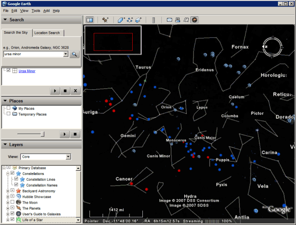

"Never before has a roadmap of the entire sky been made so readily available. Anyone interested in exploring the wonders of our universe can quickly see where the stunning objects photographed by Hubble actually dwell in the heavens. Sky in Google Earth will foster and initiate new understanding of the universe by bringing it to everyone's home computer," said Dr. Carol Christian from the Space Telescope Science Institute.
After launching the application, click on the black rounded icon from the toolbar and switch to the sky mode. Google Earth shows the sky from the current location and becomes a virtual telescope for amateur stargazers.
"This easy-to-use tool enables all Earth users to view and navigate through 100 million individual stars and 200 million galaxies. High resolution imagery and informative overlays create a unique playground for visualizing and learning about space," explains the press release.
The layers include a lot of interesting information about stars, constellations, galaxies, images from the Hubble Space Telescope.
"Never before has a roadmap of the entire sky been made so readily available. Anyone interested in exploring the wonders of our universe can quickly see where the stunning objects photographed by Hubble actually dwell in the heavens. Sky in Google Earth will foster and initiate new understanding of the universe by bringing it to everyone's home computer," said Dr. Carol Christian from the Space Telescope Science Institute.
Subscribe to:
Posts (Atom)


